Saturday 2 June 2012

A New Google Resource: World Wonders

Those of you who visit my blog will probably have picked up on the fact that I'm slightly (read: completely) obsessed with UNESCO World Heritage sites. This probably comes from being a geographer and an avid traveller. I have a vast appreciation for the myriad wonders of the world. This is why I was extremely excited when I heard about UNESCO's latest project. 

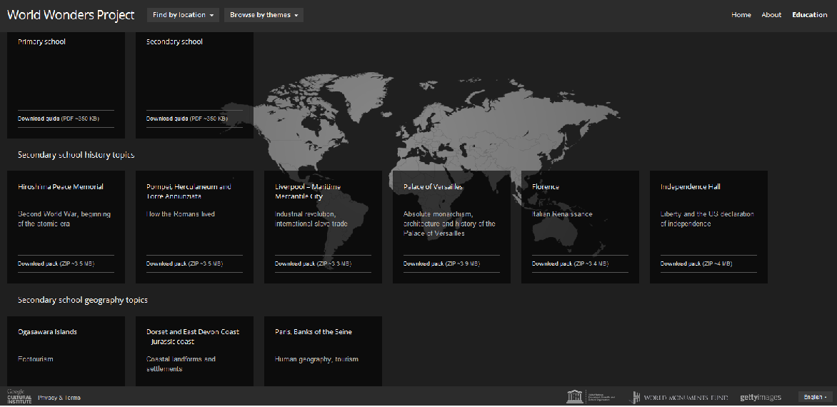
UNESCO has created a site on the World Wonders (World Heritage sites) that offers a VFT (Virtual Field Trip) experience. Check out the screenshot below - students can explore the site, plus there is background information, pictures and video resources (where applicable). You can search for locations by theme or by location. One caveat: There are no African sites and very few Asian sites. I'm assuming this will be rectified where possible at some point in the future.


To supplement this website in the classroom, they have also produced some educational resources for history and geography, with cross-curricular ideas in in their 'Primary' and 'Secondary' guides. History themes include studies of Pompeii, Versailles and the Hiroshima Peace Monument, while Geography themes include a coastal study using the Jurassic Coast of the UK. 


I was hoping to use this in the classroom with my Year 7s, given what they're currently studying (see: UNESCO World Heritage 'Should We...?' Assignment), but most of the sites that they're looking at aren't up yet. 

Limitations aside, this promises to be an enjoyable and useful classroom resource. 

Sunday 27 May 2012

Hexagon Templates - SOLO Activities

I've put together some hexagon templates of differing sizes for those who want to use them in classes for SOLO activities. I've seen some great examples of hexagon activities to check, consolidate and explore student knowledge. 

I've made small, medium, large, extra large, and extra extra large hexagons. Feel free to download them for use in your classes. They are all A4 templates. 

Small - 18 hexagons
Medium - 10 hexagons
Large - 4 hexagons
Extra Large - 2 hexagons
Extra Extra Large - 1 hexagon

Saturday 26 May 2012

#geogsolo

This is why I love Twitter. It's a dynamic environment filled with intelligent, enthusiastic and committed people. 

A short conversation by @johnsayers regarding his idea to create a website of SOLO-based resources for the Geography classroom spiralled into a global effort, with our first #geogsolo (our Twitter hashtag) meeting scheduled for the 16th of June at 12pm GMT/ 3pm UAE/ 9pm AUS EST. 

Follow the #geogsolo hashtag on Twitter to find out more, to locate resources, and to meet other practitioners. The more the merrier!

Friday 25 May 2012

UNESCO World Heritage Sites Task

I just designed a task for my Year 7s around the UNESCO World Heritage Sites. The focus here is on developing and utilising higher-order critical thinking skills, such as evaluating and creating. As this is quite a lot of work for KS3/Lower Secondary students, mine will be presenting it in groups (encourage the use of technology in presenting - PowerPoint, Prezi, Animoto, Google Presentations, etc). 

The Lowdown:

Students must answer the following key questions:

  • Why should we care about protecting cultural and natural sites?
  • What do you think should be the key criteria for protecting a place? (Students will design their own key criteria re: what makes a place worth saving)
  • Can UNESCO's criteria be made any better? (Students will evaluate UNESCO's criteria, providing an overall opinion, reasons, and potential improvements)
They will also need to research a current UNESCO World Heritage site (or a location of their own choosing that they feel needs protection), provide background information on their site, and evaluate it using their own list of criteria to decide whether it is worth protecting/preserving. 


Other things:

I would also recommend printing out images of World Heritage sites to provide inspiration. 

You will need to scaffold and model thinking - I talk it through with my students and use Project Zero thinking techniques e.g. Think, Pair, Share, plus graphic organisers and coloured pens to get students generating, sharing, and writing down their ideas. You will probably also need to discuss the UNESCO criteria with students - I've greatly simplified them, but the language is still quite formal - if anyone can simplify them further, I'd love to get in touch with you. 

We've just started, so I will let people know how it goes and share insights re: the final product. You could probably get 8s and 9s to do this as well. 

The assignment handouts are available below - feel free to modify them for use in your classrooms. 

Resource 1: Should We...? Task
Resource 2: Group/Record Sheet
Resource 3: UNESCO Criteria Sheet (Simplified)

UPDATE:

Resource 4: 'NIP' Graphic Organiser (use this for evaluating UNESCO's criteria)
Resource 5: Should We...? Criteria Sheet (Mark sheet)

Depending on which sites you're looking at, this website on World Wonders + Google Earth/Maps could be very useful. It doesn't have any African sites, and very few Asian ones, but there are plenty from N. America and Europe on there. It provides students with a VFT (Virtual Field Trip) experience. 

Wednesday 16 May 2012

Scoop.it!

One of the many lovely Twitter users that I follow, @geographynerd (Rebecca Nicholas) clued me into Scoop.it. I'd seen it before, but had never really thought about using it. Bec explained how easy it was to use and voila! I was hooked. I've now started my own Scoop.it at Geography - The World Around Us. While I use mine to curate articles on all aspects of Geography, Bec has demonstrated how it can easily be used for a class. She collates articles regarding climate change for one of her Geography classes, so they have a constant supple of quality links and source material. You can find it here. 

Enjoy!

Saturday 5 May 2012

Google Apps in Education

Hi all,

Having recently attended a PD on Google Apps I'm interested in putting together a resource looking at the ways that Google Apps can be used in education, both in a classroom and at a staff/management level. I'd post it here in a Google doc (with credit given for all suggestions used) and on TES resources.

What I want to know is:

1) How might you use Google Apps in a classroom? (Theoretical ideas)
2) How people have used Google Apps in a classroom, and
3) How people have used Google Apps at a staff/management level.

All ideas welcome - feel free to communicate your ideas using the comment section of this post, by emailing me (email in the column on the left) or by tweeting me @thegeophyte.

Thank you!

Thursday 3 May 2012

Derwentwater: Change over Time

Since the drought in the UK is quite topical at the moment, I thought I'd put up two of my photos of the Lake District. The first one was taken in 2007 and the second three years later, in 2010. These images are of the southern end of Derwentwater, not too far from Lodore Falls. The difference in water level is quite obvious. The summer of 2010 (against all weather predictions) was very hot by UK standards. One local shopkeeper told me that several of the jetties on the lake were rendered unusable by the dropping water levels. 


In 2007


In 2010

Feel free to use these images in your classrooms to demonstrate change over time and the effects of drought in the UK. I've made a quick worksheet using these images that can be downloaded via the link below:

Monday 30 April 2012

Changing Perspectives of Africa

Africa has long had a fairly unwanted image in the Western world. Fascination with the 'Dark Continent' aside, the general public tends to associate several things with Africa: famine, poverty, and war. A history of colonial oppression, inequality and genocide has cast a pall over the continent. What a lot of people don't realise is that Africa is a diverse continent, bubbling with culture. 

This is not to say that Africa does not have problems. It most assuredly does. The continent does face conflict, poverty and myriad other problems. However, we need to start looking beyond this 'face' to see the other real Africa - where people love, laugh, work, and learn. As geography teachers, it is very important that we present nuanced views and images of the world. To that end, I have compiled resources that look at daily life in Africa and African perspectives. 

If you have more, feel free to email them to me or tweet me a link to the resources using the details on the left. Alternatively, paste the link in the comments box. I hope that you find these useful. 

Changing Perspectives looks at families living in the North-East of England. 

African Dream - A great series of articles and interviews on the BBC with African entrepreneurs and how they succeeded (BBC, 2012)

Grassroot entrepreneurs in Africa (BBC, 2002)

African Lives - A collection of articles by the Washington Post (1997) that look at both good and bad aspects of life on the continent. 

Africa: My World - 4 photojournals of daily life at schools in 4 different African countries (PBS)

African Success is a database of successful African personalities

Video - African Men. Hollywood Stereotypes - well worth watching:

Video - Africa debate: What do Venezuelans think of Africa? (BBC, 2012)

Video - Africa debate: What do Pakistanis think of Africa? (BBC, 2012)

Video - BBC debate: Is Africa's global image justified? (BBC, 2012)

Pictures: The many images of Africa's daily life (BBC, 2012)

Pictures: Africa Media Online - the pictures are professional images and not free, but are still worth perusing - the 'daily life' ones are particularly good/useful. 

Pictures: Images of life in rural Ghana, where the photographer lived for 8 months. 

An eclectic collection of lessons on Africa - perhaps a touch outdated and also geared towards a younger audience; however, there are still some good ideas and resources here.